HumAnS Lab

header


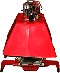
Arctic Navigation

Climate change is one of the major concerns of the scientific community.
As such, scientists are always looking for new ways to collect weather
data to help model and predict the impact of our society on the global
climate. Specifically, weather data collected from arctic regions is
considered valuable, as glacial regions are more sensitive to the
effects of climate change. Recently, scientists have been considering
deploying multiple robotic weather stations to Greenland or Antarctica
to aid in this data collection.

For such a robotic system to be viable, each rover must be able to
navigate to a desired location without relying on a human operator.
However, glacial terrains present a variety of hazards apart from the
obvious temperature extremes. Hard-packed snow dunes and softer snow
drifts present steep inclines that must be overcome, vertical cracks in
the ice sheet can easily swallow a small rover, and varying lighting
conditions in the all-white environment make detecting these hazards
difficult.

Nonetheless, current research is focused on developing a vision-based
navigation system for arctic robots. Techniques for amplifying subtle
terrain texture have proven effective at uncovering potential hazards,
and methods for extracting visual landmarks in the snow-covered terrain
have enabled rovers to track their progress towards their goal.
Currently, methods are being explored to allow the rovers to create a
‘mental’ 3-D model the terrain. With this model the robots can plan
efficient routes to their goal that minimizes traversal through
treacherous terrain.

Pictures

arctic3arctic2arctic1arctic4


About | Perception and Reasoning | Human-System Interaction | Space and Field Robotics | People | Home
Walker Version 1 Snowmotes Version 3 and 4 Feild Trials

<![CDATA[

]]>